Assignment 3: The decline and locational shift of automotive theft: A local level analysis
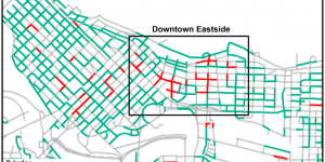
Hodgkinson et al. aims to investigate the changes in the spatial patterns of auto theft in Vancouver, British Columbia between the years 2003 to 2013. The team of researches wanted to determine what areas are declining and why they are declining to understand what strategies are effective for reducing crime levels in certain areas.
Lab 3: Crime Analysis of Ottawa Using CrimeStat (2005-2006)
In this lab, we used CrimeStat to conduct several analyses to identify the relative risk of and crime hot spots in Ottawa.
Assignment 2: Understanding Factors Affecting the Outbreak of Malaria Using Locally-Compensated Ridge Geographically Weighted Regression: Case Study in DakNong, Vietnam
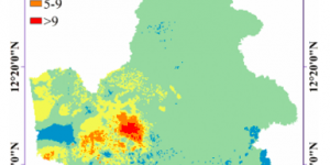
Hoang et al. conducted a study in Vietnam, specifically in the DakNong province, to analyze factors that affect the outbreak of malaria.
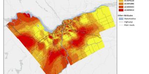
Lab 2: Evaluating Language Scores of Children in Vancouver, BC
In the analysis, we have used ordinary least squares (OLS) and geographically-weighted regression (GWR) to determine the relationship between language scores and factors that affect a child’s development across Vancouver.


Assignment 1: Statistical models of landscape pattern metrics, with applications to regional scale dynamic forest simulations
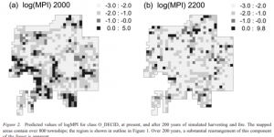
In Cumming and Vernier’s research, they address the spatial resolution and scaling problem in forest management. The study focusses specifically on the southern edge of a large forest estate in northeast Alberta.
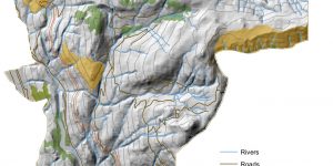
Lab 1: Land use Change in Edmonton, Alberta (1966 - 1976)
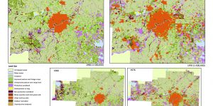
In this lab, we explored how the landscape around Edmonton, Alberta has changed over time from 1966 to 1976.

Week Two: Why is Geography Important?

Here is a summary of what we talked about in our lecture on the importance of geography!
Tutorial 1: Hot Spot of Heart Disease in Southern United States By County from 1999 to 2016
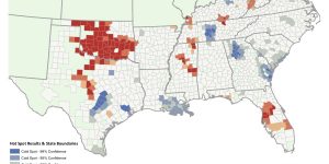
Maps were made to show the hotspots for heart disease in the Southern United States for each year from 1999 to 2016.

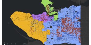
Equity and Going Green: Remaining Sustainable and Accessible in Vancouver
"As sustainable initiatives are becoming increasingly political and therefore carried out for and by those with authority and privilege, it is apparent that urban green projects are not meeting the needs or accessible for lower class, marginalized, or disabled populations. This paper intends to examine the ways in which the Metro Vancouver area and its authorities apply and encourage sustainability."
Tsunami Impact Assessment on Vancouver Island’s West Coast
Final project analyzing the impacts of the 20m tsunami expected to hit West Coast Vancouver Island.
Environmental Impact Assessment (EIA)
Acquire, Parse, Filter, Mine, Represent, Refine, Interact. An environmental impact assessment on the proposed Garibaldi at Squamish Ski Mountain Resort
Housing Affordability
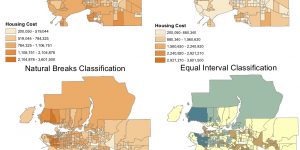
Working with Census Data: tables, joins, classification, visualization. This project analyzes the affordability of housing in Vancouver.
Planning for Flooding and Storm Surge
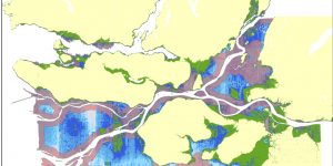
Spatial Analysis, Map Layout, Editing. The project analyzes the flooding zones in Metro Vancouver. A specific area that I looked into was False Creek, where the new St. Paul's Hospital is to be built.